Golden Spike Announces Gregory River Drilling Results
Vancouver, British Columbia, February 13, 2025 – Golden Spike Resources Corp. (CSE: GLDS) (OTCQB: GSPRF) (Frankfurt: L5Y) (“Golden Spike” or the “Company”) is pleased to announce the final assay results from the 2024 diamond drilling program at the Gregory River volcanogenic massive sulphide (“VMS”) property (“the Property”), located on the west side of Newfoundland. Wide-spaced, reconnaissance-style drilling was completed at three target areas; the Steep Brook and Lode 9 VMS targets, and the Vein Zone.
Selected highlights from the drill hole analytical results include:
Steep Brook
- 0.33% copper, 0.04 g/t gold over 11.15 m (hole GR-24-003, 69.85m to 81.0 m)
- Including, 1.29% copper, 0.19 g/t gold over 1.50 m (69.85m to 71.35m)
- and 1.37% copper, 0.02 g/t gold over 0.50 m (79.0m to 79.5m)
- 0.40% copper, 0.08 g/t gold over 11.0 m (hole GR-24-005, 19.0m to 30.0m)
- Including, 1.26% copper, 0.11 g/t gold over 1.47 m (27.27m to 28.75m)
Lode 9:
- 1.49% copper, 0.45 g/t gold over 2.88 m (hole GR-24-006, 38.68m to 41.56m)
- Including, 2.40% copper, 0.67 g/t gold over 1.56 m (40.0m to 41.56m)
- Including, 4.63% copper, 1.24 g/t gold over 0.56 m (41.0m to 41.56m)
- 0.34% copper, 0.18 g/t gold over 9.43 m (hole GR-24-006, 78.9m to 88.33m)
- Including 1.49% copper, 0.34g/t gold over 0.5m (81.0m to 81.50m)
- and 0.99% copper, 0.85 g/t gold over 0.75 m (87.58m to 88.33m)
- 1.46% copper, 0.04 g/t gold over 0.75 m (hole GR-24-006, 169.0m to 169.75m)
- 0.40% copper, 0.31g/t gold, 1.85% zinc over 0.64 m (hole GR-24-007, 35.16 to 35.8 m)
- 0.33% copper, 0.25 g/t gold, over 8 m (hole GR-24-007, 122.0m to 130.0m)
- Including, 1.17% copper, 0.47 g/t gold over 0.5 m (122.0m to 122.5m)
- and 0.45% copper, 0.40 g/t gold, over 3 m (127.0m to 130.0m)
Vein Zone:
- 0.27% copper over 5.95 m (hole GR-24-009, 76.05m to 82.0m)
- 1.25% copper over 0.5m (hole GR-24-009, 93.8m to 94.3m)
Keith Anderson, President and CEO of Golden Spike Resources, commented:
“Our inaugural drilling program at Gregory River has strongly validated our exploration model and reinforced our confidence in the project’s potential. The discovery of multiple sulphide-mineralized zones, particularly at Steep Brook and Lode 9, highlights the significant opportunity before us. With vast areas of the property still unexplored and only shallow depths tested, we are just beginning to unlock what we believe could be a major VMS system. Golden Spike remains committed to advancing exploration in a systematic and responsible manner, and we are excited to build on these promising results as we move into our 2025 exploration program. Our team will continue working with the drill results and additional data to further refine our understanding of the property’s mineralization potential and guide our next steps in unlocking its full value.”
Diamond Drilling Results
Diamond drilling was the second phase of the 2024 exploration program and comprised of 10 reconnaissance diamond drill holes, totaling 1,927 m, of which five holes (921 m) are at Steep Brook, three holes (654 m) are at Lode 9 and two holes (352 m) are at the Vein Zone (Figure 1). Drill holes were designed to target multiple layers of anomalies, including IP anomalies, surface rock sampling results, soil anomalies, and geological interpretations. In most areas the drill holes were the first ever recorded and the vast majority of the Property remains mostly unexplored. Drilling was curtailed prior to last two holes being drilled due to the onset of winter conditions, making supply logistics difficult and compromising the health and safety of the field crew.
The Company is very encouraged by the results of this initial drilling program. Most of the eight, wide-spaced, drill holes testing VMS targets at Steep Brook and Lode 9 intersected varying amounts of disseminated and/or fracture/veinlet-hosted to semi-massive pyrite +/-chalcopyrite-sphalerite mineralization over varying lengths. The sulphide zones tend to be coincident with the induced polarization/resistivity (“IP”) anomalies from this summer’s Phase 1 program (refer to news release “Golden Spike Announces IP Survey Results from Gregory River”, October 17, 2024) and occur in a geological environment consistent with our target, Cyprus-type, VMS mineralization. Several intercepts include copper values greater than 1.0% copper over lengths ranging from 0.5 m to 2.90 m. These are hosted within wider, lower grade intervals, ranging between approximately 0.20% to 0.40% copper over drilled widths reaching 12 m. A full list of anomalous assay results is provided in Table 1.
Most of the mineralization was likely sourced along regional structural conduits, such as the Gregory River Fault and its associated splays, and deposited in strata-bound horizons and structures near the basalt-gabbro contact, or in footwall stringer zones, along the 11 km strike length of the Gregory River VMS target corridor. The drilling program supports the Company’s belief that a significant amount of sulphide mineralization was deposited in the area and that the best remains to be discovered. The next steps will be to interpret the layers of data collected during the recent programs and use these to vector into areas where the mineralization could be wider and higher in grade.
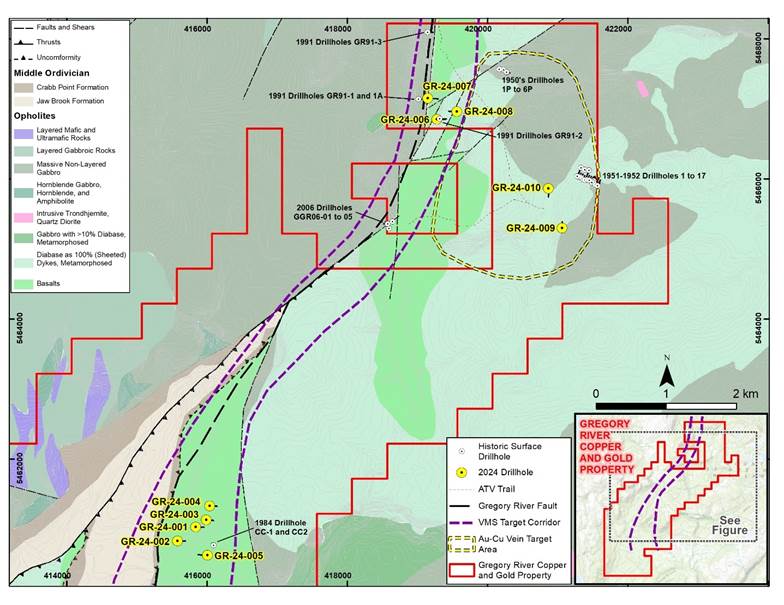
Figure 1: Location of 2024 Gregory River Property Drill Holes
Steep Brook Drilling
All five drill holes at Steep Brook targeted first priority IP anomalies, coincident with historical copper soil anomalies (Figure 2). Most holes crossed thick sequences of chlorite-carbonate altered basaltic flows, pillows and breccia with minor gabbro. Disseminated and minor blebs of pyrite and chalcopyrite occur in several sections of the chlorite altered basalt, as well as fracture-controlled sulphide stringers and sulphide mineralized quartz-carbonate veinlets. Although all five holes intersected anomalous copper +/-gold grades, assays from drill holes GR-24-003 and -005 returned the strongest copper mineralization, as shown in Table 1.
Drill hole GR-24-003 intersected an 11.15 m interval between 69.85 m and 81.0 m that assayed 0.33% copper and 0.04 g/t gold. Within this, are two higher grade intervals, including 1.29% copper and 0.19 g/t gold over 1.5 m and 1.37% copper and 0.02 g/t gold over 0.5 m (Figure 3).
Drill hole GR-24-05 intersected one main sulphide zone, starting from the base of the overburden, at about 10 m, to approximately 42 m down the hole. Within this are several copper mineralized intervals, including 0.40% copper and 0.08 g/t gold over 11 m (19.0 m to 30.0 m), and 1.26% copper and 0.11 g/t gold over 1.47 m (27.28 m to 28.75 m). Additional anomalous intervals are shown on Figure 4 and in Table 1.
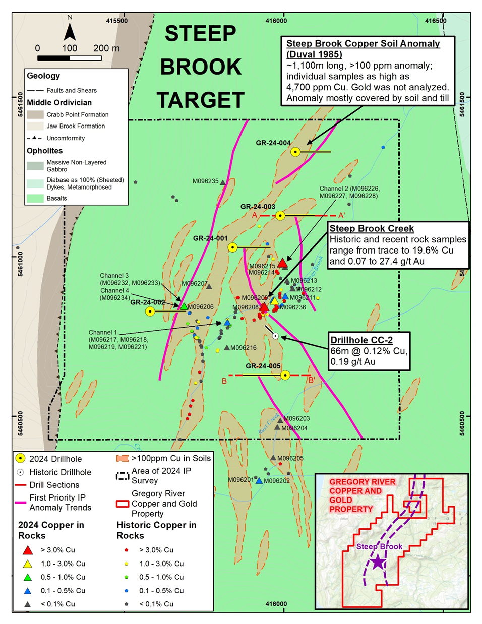
Figure 2: Location of Steep Brook Drill Holes
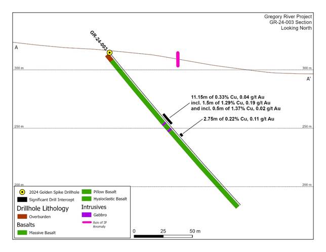
Figure 3: Cross Section Showing Steep Brook Drill Hole GR-24-003
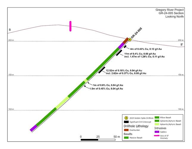
Figure 4: Cross Section Showing Steep Brook Drill Hole GR-24-005
Lode 9 Drilling
Drill hole GR-24-006, was collared approximately 75 m west of the Lode 9 showing, and 40 m west of historical drillhole GR-91-02, which returned 7.2 m grading 2.12% copper and 0.60 g/t gold (Figure 5). As shown on Figure 6, Golden Spike hole GR-24-006 crossed through two significant copper mineralized intervals, the first was from 38.68m and returned 1.49% copper and 0.45 g/t gold over 2.88 m, including 2.40% copper and 0.67 g/t gold over 1.56 m. This latter interval included a 0.56 m interval, which assayed 4.63% copper and 1.24 g/t gold. Further down the hole, at 78.9 m, the interpreted down-dip extension of the Lode 9 prospect was intersected at the basalt-gabbro contact and returned 0.34% copper and 0.18 g/t gold over 9.43 m. Within this interval are two higher grade intervals in including 1.49% copper and 0.34 g/t gold over 0.5 m and 0.99% copper and 0.85 g/t gold over 0.75 m. The Lode 9 mineralized zone is interpreted to be dipping approximately 60 degrees to the west and the GR-24-006 interval is approximately 50m down-dip from the Lode 9 surface outcrop. It is very encouraging that down-dip continuity of the mineralization is established, and that the mineralization remains open in all directions.
Drill hole GR-24-007, was drilled 330 m northwest of hole GR-24-006 and tested the westernmost IP anomaly and a strong copper-zinc soil anomaly from Noranda’s program in 1991 (Figure 7). Noranda had also drilled historical holes GR-91-01 and -01A about 135 m west of GR-24-007 and intersected a 10m wide cherty exhalate, which is a silica-rich horizon common near the upper portions of VMS deposits. GR-24-007 crossed through mostly basalts and brecciated zones and intersected a series of 2 m -16 m wide anomalous zinc horizons, with zinc grades ranging from 0.10% to 0.72%, and occasional associated anomalous copper grades. The best copper interval was between 122 m and 130 m, which assayed 0.33% copper and 0.25 g/t gold, including 1.17% copper and 0.47 g/t gold over 0.5 m.
Drill hole GR-24-008 was drilled towards the west and remained mostly in gabbro, with only a few anomalous intervals of copper, zinc and gold intersected. The drill hole was targeting an IP anomaly, close to the gabbro-basalt contact, where mineralization was expected, but the contact was not reached.
A fourth hole, planned to test an IP anomaly in the northeast portion of the target, was postponed due to the winter conditions. It is scheduled to be completed during the next drilling phase.
Vein Zone Drilling
Drill hole GR-24-009 was drilled to test the Court C prospect, which had never previously been drilled. The hole targeted a steeply north dipping, 50 m wide, IP chargeability anomaly, directly below the Court C prospect. The drill hole crossed a 40 m thick sequence of gabbro with intermittent zones of quartz-carbonate veinlets and fractures with varying amounts of disseminated pyrite and occasional chalcopyrite. Several intervals within this zone returned anomalous values of copper ranging from 0.14% to 1.25% over widths ranging between approximately 0.5 m and 6.0 m (Table 1). This supports the concept that a much wider target exists at the Vein Zone than the historical sampling suggested.
Drill hole GR-24-010 tested another IP anomaly, in an area with no outcrops and no previous known mineralization. The hole crossed mainly massive basalt with quartz-carbonate veins and fractures throughout, however no significant mineralization was intersected. A third hole was planned to test the Court A Prospect; however, this hole was postponed until the next drill program due to weather constraints.
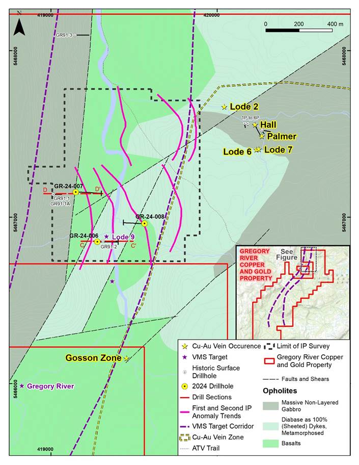
Figure 5: Location of Lode 9 Drill Holes
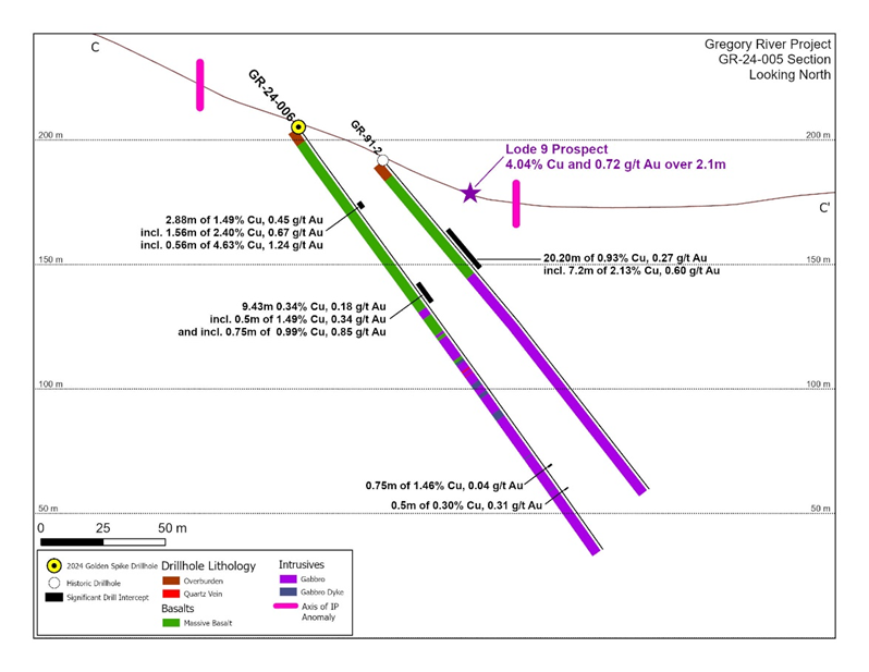
Figure 6: Cross Section Showing Lode 9 Drill Hole GR-24-006
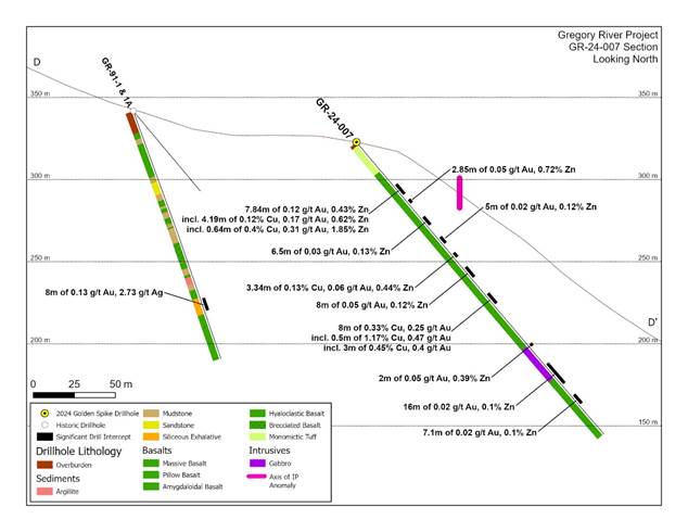
Figure 7: Cross Section Showing Lode 9 Drill Hole GR-24-007
Table 1: Gregory River 2024 Diamond Drilling – Significant Intercepts
Drill Hole | From (m) | To (m) | Length (m) | Au (g/t) | Cu (%) | Zn (%) |
Steep Brook |
|
|
|
|
|
|
GR-24-001 | 108 | 114.86 | 6.86 | 0.04 | 0.14 | 0.01 |
GR-24-001 | 167 | 170 | 3 | --- | 0.03 | 0.24 |
GR-24-002 | 84.44 | 85.2 | 0.76 | 1.19 | 0.02 | 0.08 |
GR-24-002 | 127 | 134 | 7 | 0.01 | 0.03 | 0.15 |
including | 127 | 127.5 | 0.5 | 0.01 | 0.18 | 1.21 |
GR-24-003 | 69.85 | 81 | 11.15 | 0.04 | 0.33 | 0.01 |
including | 69.85 | 71.35 | 1.5 | 0.19 | 1.29 | 0.01 |
and | 79 | 79.5 | 0.5 | 0.02 | 1.37 | 0.01 |
GR-24-003 | 92.2 | 94.95 | 2.75 | 0.11 | 0.22 | 0.01 |
GR-24-004 | 8.83 | 9.37 | 0.54 | 0.06 | 0.24 | 0.01 |
GR-24-004 | 48.59 | 50.62 | 2.03 | 0.45 | 0.04 | 0.05 |
GR-24-005 | 10 | 14 | 4 | 0.12 | 0.43 | 0.02 |
GR-24-005 | 19 | 30 | 11 | 0.08 | 0.40 | 0.03 |
including | 27.28 | 28.75 | 1.47 | 0.11 | 1.26 | 0.09 |
GR-24-005 | 53.6 | 66.12 | 12.52 | 0.04 | 0.18 | 0.01 |
including | 53.6 | 56.22 | 2.62 | 0.05 | 0.37 | 0.02 |
GR-24-005 | 86.3 | 87.3 | 1 | 0.04 | 0.60 | 0.01 |
GR-24-005 | 93 | 94.5 | 1.5 | 0.04 | 0.45 | 0.01 |
Lode 9 |
|
|
|
|
|
|
GR-24-006 | 38.68 | 41.56 | 2.88 | 0.45 | 1.49 | 0.03 |
including | 40 | 41.56 | 1.56 | 0.67 | 2.40 | 0.05 |
including | 41 | 41.56 | 0.56 | 1.24 | 4.63 | 0.08 |
GR-24-006 | 78.9 | 88.33 | 9.43 | 0.18 | 0.34 | 0.02 |
including | 81 | 81.5 | 0.5 | 0.34 | 1.49 | 0.07 |
and | 87.58 | 88.33 | 0.75 | 0.85 | 0.99 | 0.07 |
GR-24-006 | 169 | 169.75 | 0.75 | 0.04 | 1.46 | 0.04 |
GR-24-006 | 180.5 | 181 | 0.5 | 0.31 | 0.30 | 0.02 |
GR-24-007 | 35.16 | 43 | 7.84 | 0.12 | 0.08 | 0.43 |
including | 35.16 | 39.35 | 4.19 | 0.17 | 0.12 | 0.62 |
including | 35.16 | 35.8 | 0.64 | 0.31 | 0.40 | 1.85 |
GR-24-007 | 47.15 | 50 | 2.85 | 0.05 | 0.02 | 0.72 |
GR-24-007 | 61 | 67.5 | 6.5 | 0.03 | 0.02 | 0.13 |
GR-24-007 | 77 | 82 | 5 | 0.02 | 0.03 | 0.12 |
GR-24-007 | 89.66 | 93 | 3.34 | 0.06 | 0.13 | 0.44 |
GR-24-007 | 101 | 109 | 8 | 0.05 | 0.02 | 0.12 |
GR-24-007 | 122 | 130 | 8 | 0.25 | 0.33 | 0.09 |
including | 122 | 122.5 | 0.5 | 0.47 | 1.17 | 0.03 |
and | 127 | 130 | 3 | 0.40 | 0.45 | 0.06 |
Table 1 Continued
Drill Hole | From (m) | To (m) | Length (m) | Au (g/t) | Cu (%) | Zn (%) |
|
|
|
|
|
|
|
GR-24-007 | 162 | 164 | 2 | 0.05 | 0.08 | 0.39 |
GR-24-007 | 178 | 194 | 16 | 0.02 | 0.03 | 0.10 |
GR-24-007 | 203 | 210.1 | 7.1 | 0.02 | 0.01 | 0.10 |
Vein Zone |
|
|
|
|
|
|
GR-24-008 | 209 | 210 | 1 | 0.07 | 0.19 | 0.03 |
GR-24-008 | 203.82 | 204.75 | 0.93 | 0.22 | 0.26 | 0.26 |
GR-24-009 | 76.05 | 82 | 5.95 | 0.02 | 0.27 | --- |
GR-24-009 | 93.8 | 94.3 | 0.5 | 0.03 | 1.25 | 0.01 |
GR-24-009 | 96 | 96.5 | 0.5 | 0.03 | 0.20 | --- |
GR-24-009 | 103 | 105 | 2 | --- | 0.14 | --- |
GR-24-009 | 110.3 | 110.8 | 0.5 | --- | 0.30 | --- |
GR-24-009 | 132 | 133 | 1 | --- | 0.23 | --- |
GR-24-010 | No | significant | results |
|
|
|
Notes: All lengths are drilled lengths; insufficient information exists to accurately determine true widths of the drill hole intercepts, however based on the modelled geophysical anomalies and geological interpretations they are estimated to be in the range of 60% to 90% of the drilled lengths; most intervals are accompanied by anomalous values of arsenic, in the range of trace to 5,600 ppm, averaging around 750 ppm.
Gregory River Property Drilling Information
Diamond drilling was conducted by Rally Drilling Services Inc., from October 28 to December 16, 2024, during which time 10 holes totaling 1,927 m were completed. This includes five holes totalling 921 m at Steep Brook, three holes totalling 654 m at Lode 9, and two holes totaling 352 m at the Vein Zone (Figure 1). The drill holes were designed to test multiple anomalies, including first priority Induced Polarization/Resistivity (“IP”) anomalies (refer to press release “Golden Spike Announces IP Survey Results from Gregory River, October 17, 2024) historical and Company-collected surface rock and soil samples, and historical drill results.
Since the companies that collected the historical drilling data and surface samples were mostly mid-size to large, reputable companies that would have had sampling methodologies and quality control processes in place that were considered industry-standard for that time, the QP feels that it is reasonable to report these results as historical and to use them as a guide for on-going exploration at these prospects. During this summer’s sampling program, a portion of the historical sample sites were re-sampled by Golden Spike, further supporting the general range of grades historically reported. Furthermore, during January 2023 the Company relogged and sampled a portion of historical drill hole CC-2, returning a similar range of copper values and providing support for the historical grades in this hole.
All of the recent holes were drilled at moderate dips, ranging between -47 and -55 degrees, to down-hole depths ranging between 152 m and 233 m. Drill hole azimuths were variable depending upon the target. Drill hole sample lengths range between 0.40 m and 2.25 m, but average around 1.0 m. All drill holes had excellent core recovery, averaging greater than 98% recovery. Table 2 summarizes the drill hole details and Figures 1, 2 and 5 show the locations of the drill holes.
All core samples intervals were saw-cut by Golden Spike contractors at the base camp in Trout River, then immediately bagged and sealed shut. On an approximate weekly basis, samples were delivered by Golden Spike contractors to SGS Natural Resources (“SGS”) in Grand Falls, Newfoundland for sample preparation. Samples were crushed to 75% passing 2mm, and a 250 g split was pulverized to 85% passing 75 microns (SGS preparation code PRP89). The pulp was shipped directly by SGS to their laboratory in Burnaby, BC, where samples were analysed for gold by 30-gram fire assay with an AAS finish (SGS code GE FAA30V5) and for 33 elements by ICP-AES, using a 4-acid digestion (SGS code GE ICP40Q12). The ICP analysis included target elements, such as copper, zinc and silver, as well as various pathfinder and other elements. Overlimits for copper and zinc were further analysed by 4-acid digestion ICP-AES (SGS code GO_ICP42Q100). SGS is an internationally recognized laboratory and is independent of Golden Spike. SGS conforms to the requirements of ISO/IEC 17025:2017. Scopes of Accredited tests are site specific, please visit Accredited Organizations | Standards Council of Canada (scc-ccn.ca).
The Company has incorporated a rigorous quality assurance/quality control (“QA/QC”) program during the drill hole sampling, which includes the regular insertion of Company standards (commercially purchased certified reference material), coarse blanks, and duplicates (1/4 core twin, crush and pulp duplicates) at a frequency of approximately 3 QAQC insertions per 20 samples.
Table 2: Gregory River 2024 Diamond Drilling – Collar Information
Drill Hole | UTM EASTING | UTM NORTHING | Elevation (masl) | Length (m) | Azimuth (degrees) | Dip (degrees) | Target |
GR24-001 | 415840 | 5461029 | 285 | 206 | 90 | -55 | Steep Brook |
GR24-002 | 415581 | 5460829 | 229 | 175 | 90 | -50 | Steep Brook |
GR24-003 | 415989 | 5461129 | 288 | 172 | 90 | -51 | Steep Brook |
GR24-004 | 416037 | 5461329 | 341 | 172 | 90 | -50 | Steep Brook |
GR24-005 | 416005 | 5460629 | 193 | 196 | 270 | -47 | Steep Brook |
GR24-006 | 419280 | 5466851 | 203 | 209 | 90 | -55 | Lode 9 |
GR24-007 | 419150 | 5467150 | 311 | 233 | 90 | -50 | Lode 9 |
GR24-008 | 419564 | 5466961 | 187 | 212 | 270 | -55 | Lode 9 |
GR24-009 | 421062 | 5465297 | 442 | 152 | 360 | -50 | Vein Zone |
GR24-010 | 420866 | 5465861 | 366 | 200 | 180 | -51 | Vein Zone |
Total | Drilling |
|
| 1,927 |
|
|
|
Notes: Collar coordinates are reported using NAD83 datum; collar information for the five Steep Brook holes was previously released on November 26, 2024.
Next Steps
With the completion of the drilling program, the Golden Spike technical team will now focus on the integration and technical analysis of the drill results, incorporating data from surface geochemistry, field mapping and ground and airborne geophysics to develop vectors towards wider and higher-grade mineralization and to identify new exploration targets. Additional soil sampling, rock sampling, geological mapping and diamond drilling are all planned for the 2025 exploration program. Exploration budgets are currently being developed and the full exploration plan will be announced once finalized and board approval received.
Qualified Person
The scientific and technical information in this news release has been reviewed and approved for disclosure by Mr. Robert Cinits, P.Geo, a Director of the Company and a "Qualified Person" within the meaning of National Instrument 43-101 - Standards of Disclosure for Mineral Projects.
JEA Program
Golden Spike Resources Corp. is deeply appreciative of being selected as a recipient of the Newfoundland Junior Exploration Assistance (JEA) Program. The anticipated financial support of $95,691.86 represents a crucial step in advancing our exploration initiatives in Newfoundland, and we are incredibly grateful for the support provided by the Government of Newfoundland and Labrador. This opportunity strengthens our commitment to responsible and innovative exploration in the region, and we look forward to the positive impact this assistance will have on our efforts. We thank the government for their trust and confidence in our vision and ongoing work.
About Golden Spike
Golden Spike Resources Corp. (CSE:GLDS), (OTCQB: GSPRF), (Frankfurt: L5Y) is a Canadian mineral exploration company focused on identifying, acquiring and unlocking value in mineral opportunities in Canada and other low-risk jurisdictions. The Company currently holds 100% interest in the 5,175-hectare Gregory River Property in Newfoundland, strategically centered over an approximate 11-kilometre-long stretch of the Gregory River VMS-belt, a north-northeast trending corridor of very prospective ground with potential to host Cyprus-type polymetallic VMS deposits. In addition, the Property hosts a cluster of historically explored, high-grade, copper ±gold vein structures. Golden Spike Resources remains dedicated to sustainable exploration practices and continues to collaborate with local communities, consultants, and stakeholders as it progresses its exploration initiatives.
For further information, please contact: Keith Anderson, President, Golden Spike Resources Corp. Tel: 604-786-7774, Email: kanderson7774@gmail.com
Website: https://www.goldenspikeresources.com
ON BEHALF OF THE BOARD OF DIRECTORS
Keith Anderson
Golden Spike Resources Corp.
830 - 1100 Melville St.,
Vancouver, BC, V6E 4A6
+1 (604) 786-7774
info@goldenspikeresources.com
www.goldenspikeresources.com
“Neither the Canadian Securities Exchange (the “CSE”) nor its Regulation Services Provider (as that term is defined in policies of the CSE) accepts responsibility for the adequacy or accuracy of this release.”
Cautionary Note Regarding Forward-Looking Statements
This release includes certain statements and information that may constitute forward-looking information within the meaning of applicable Canadian securities laws. Forward-looking statements relate to future events or future performance and reflect the expectations or beliefs of management of the Company regarding future events. Generally, forward-looking statements and information can be identified by the use of forward-looking terminology such as “intends” or “anticipates”, or variations of such words and phrases or statements that certain actions, events or results “may”, “could”, “should”, “would” occur.
Additionally, forward-looking information involve a variety of known and unknown risks, uncertainties and other factors which may cause the actual results to be materially different from any future plans, intentions, activities, results, performance or achievements expressed or implied by such forward-looking statements. Such risks include, without limitation: the volatility of global capital markets, political instability, unanticipated costs, risks relating to the extent and duration of the conflict in Eastern Europe and its impact on global markets, the lack of availability of capital and financing, general economic, market or business conditions, adverse weather conditions, failure to maintain all necessary government permits, approvals and authorizations, failure to maintain community acceptance (including First Nations), increase in costs, litigation, failure of counterparties to perform their contractual obligations, failure of the exploration program, including the recent IP survey and the recent drilling program to result in the discovery of significant precious and/or base metal mineralization, and those risks, uncertainties and factors set forth in the Company’s disclosure record under the Company’s profile on SEDAR+ at www.sedarplus.ca . Although management of the Company has attempted to identify important factors that could cause actual results to differ materially from those contained in forward-looking statements or forward-looking information, there may be other factors that cause results not to be as anticipated, estimated or intended. Accordingly, readers should not place undue reliance on forward-looking statements and forward-looking information contained herein. Readers are cautioned that reliance on such information may not be appropriate for other purposes. The Company does not undertake to update any forward-looking statement or forward-looking information disclosed herein, except in accordance with applicable securities laws.